Ancient Dwellings in Red Rock Country

The canyons that surround Sedona are known to contain many Native American dwellings and other artifacts. Visiting these sites can be an adventureā€”especially if you donā€™t actually know where they are.

Cliff dwelling in Red Rock--Secret Mountain Wilderness.
Cliff dwelling in Red Rock–Secret Mountain Wilderness.

So we have been visiting and re-visiting some canyons in the area and trying to determine where dwellings might exist. There are several ways to do this. One is to look carefully at the cliff walls and decide if these might support a dwelling. The next is to look for faint paths created by others that lead to the hidden sites within the canyon. And the third is ask a friend who did manage to find the location!

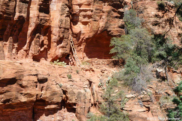
Storage cave and ladder near cliff dwellings.

Methods two and three above worked in our favor recently and we visited this set of dwellings. The first structure we visited was small and looked like it might have been used for storage. There were several small caves and alcoves nearby and these may have provided additional storage. There was also a ladder providing access to some upper caves and clefts. The ladder, although fairly modern, showed significant signs of weathering and we declined to use it.
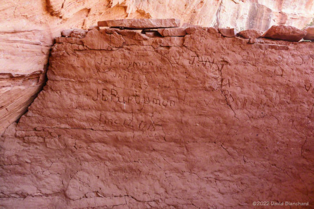
Century-old signatures on cliff dwellings.

The second structure was a well-preserved dwelling—although there was no longer a roof covering it. Inside, visitors in the early 1900’s had scratched their names and dates in the walls. That may have been acceptable then; not so much today.

As we were leaving a fairly large group approached the ruins. Time for us to leave as the quiet moments were over.
Just wandering around on East Pocket above Oak Creek Canyon

A few days ago we decided to spend the day wandering around the East Pocket area. This location overlooks the Red Rocks-Secret Mountain Wilderness on one side and Oak Creek Canyon on the other. It is a relatively flat area surrounded by steep cliffs and deep canyons. Back in the fall of 2005 we explored this area for the first time and decided that we needed to return to see more. Well, it took a few years…

To get to this location you drive south on FR231 — also known as Woody Mtn Road. From the end of the pavement it is about 28 miles to the East Pocket. The dirt road is pretty good for the first half — and not too bad over the second half.

Looking west from the East Pocket area into the Red Rock - Secret Mountain Wilderness near Sedona, Arizona.
Looking west from the East Pocket area into the Red Rock – Secret Mountain Wilderness near Sedona, Arizona.

There are no trails on the East Pocket but there are old, abandoned forest roads that are disappearing into the forest. We set off towards the south to see if we could reach the southern point and then find a way across the canyons and climb back to the flats farther south. For an idea of what the terrain looks like, follow this link toĀ Google Maps.

Upper reaches of the West Fork of Oak Creek Canyon near FR231.
We were not successful in getting across the canyon because there were some steep rock downclimbs and we were not prepared to attempt this without ropes and other climbing gear. I guess we’ll just have to return once again. The walk out to the edge was interesting and we had this fabulous view to the west of the Secret Wilderness area and the cliffs marking the edge of the Mogollon Rim.
Cautionary sign upon entering upper reaches of the West Fork of Oak Creek Canyon.

On the way home, we stopped at the bridge that crosses the extreme upper reaches of the West Fork of Oak Creek Canyon. At this point, there is no water and it consists of a rock strewn stream bed in a mountain forest of pine, spruce, and fir. There is a cautionary sign informing hikers of the difficult hiking to be found while heading downstream. We did this canyon from the upper end to the lower end about 10 years ago. It was a very challenging, but ultimately rewarding, 13-hour hike (and swim).