Grand Canyon Rim-to-Rim-to-Rim hike

With autumn winding down and winter just around the corner in northern Arizona, it was our last chance to attempt a Rim-to-Rim-to-Rim (R2R2R) hike across the Grand Canyon. Several years ago we tried the R2R2R but strong winds drove us back as we neared the North Rim. Although we were only about 3-1/2 miles from the finish, it was the prudent thing to do. Later that year, we tried again but a problem with my iliotibial band turned us around after only a few miles and we settled for a shorter hike.

Jump forward a few years and the knee issues have gone into remission. With fine weather expected and the moon just a few days past full it was time to try again.

We left the South Rim on the South Kaibab Trail (elevation 7260′) at midnight with a temperature in the low 40’s and 20–30 mph winds. Hats, gloves, and vests/parkas were required for this initial descent. At times, the wind was so fierce that we wondered if we should continue. By the time we had descended to Cedar Ridge (6060′) the wind had diminished enough to allow us to shed some of the excess gear.

With the bright moon high overhead and headlamps we were able to easily travel downhill. Traveling in the dark with a bright moon and no other hikers around is an amazing experience. It’s so quiet! We traveled quickly and arrived at the Colorado River (2480′) at 3:30 a.m. Temperatures were in the low 60’s and we took a long food and water break at Phantom Ranch before starting up the North Kaibab Trail through Bright Angel Canyon.

First light high on the canyon walls.

A short distance up stream from Phantom Ranch is “The Box.” Traveling through The Box can be the hottest part of the hike with its high and close walls of granite but it was still dark and pleasantly cool as we traversed this section of Bright Angel Canyon. The last time we were here, spring snow melt had resulted in so much water rushing down the creek that boulders were constantly moving, grinding, and crashing into each other underwater resulting in a raucous cacophony of sound. Not tonight; the gentle flow of water resulted in a delightful sound that was mesmerizing in the dark.
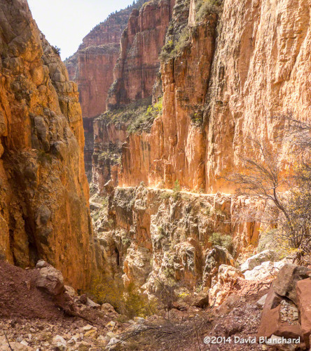
North Kaibab Trail in Roaring Springs Canyon.

We arrived at Cottonwood campground (4080′), about 8 miles from Phantom Ranch, shortly after sunrise. We learned that the water had already been shut off for the season which meant there might not be any drinking water available uphill from here. Luckily, water was still running at the Roaring Springs Pumphouse Residence (~5200′) and we refilled here.

Supai Bridge on the North Kaibab Trail in Roaring Springs Canyon.

From Phantom Ranch to Roaring Springs Residence the North Kaibab Trail is a gentle uphill climb. The trail leaves Bright Angel Canyon just past the Residence and ascends Roaring Springs Canyon which is a much steeper section of trail. The trail is narrow and perched on a nearly vertical wall with steep drops to the side. It can be very intimidating.
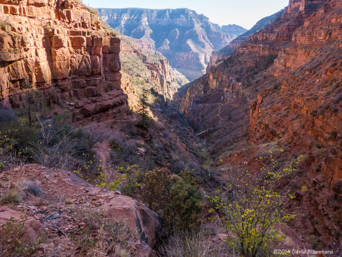
Supai Bridge in Roaring Springs Canyon as seen from North Kaibab Trail.

The trail crosses the narrow canyon at Supai Bridge and begins a series of steep switchbacks to the top. Along the way, you pass through Supai Tunnel (6800′). Not surprisingly, the water here had been turned off for the season. We arrived at the North Rim (8240′) at 12:15 p.m., where we had a leisurely lunch. Already very tired from the long climb, we now had to reverse and do it in the opposite direction.
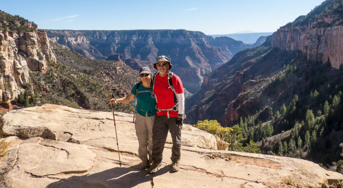
Coconino Overlook on the North Kaibab Trail.

As we descended Roaring Springs Canyon we stopped often to take photographs as the light was much better in the afternoon than it had been in the morning. The trees in the bottom of the canyon were still showing autumn colors and the narrowness of the trail as it hugged the canyon cliff was much more impressive. We stopped again at the Residence to refill our water bottles, drink, eat, and rest.

Narrow trail and steep cliffs in Roaring Springs Canyon.

Darkness descended upon us down canyon from Cottonwood Campground and, once again, we traversed The Box in the cool darkness, arriving at Phantom Ranch at 8 p.m. Many campers were hanging around waiting for the cantina to re-open so they could visit the bar. I was definitely interested in a beer but thought better of it. Instead, I lay down on the picnic bench to rest and, not too surprisingly, fell asleep, awakening around 9 p.m.
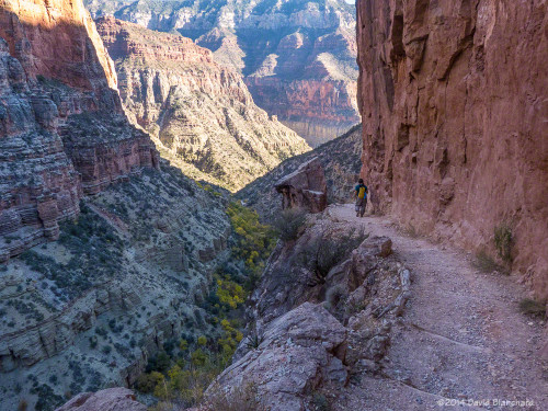
Narrow trail, steep cliffs, and autumn colors on the trees in Roaring Springs Canyon.

After drinking lots of water, consuming as many calories as we could, and filling our water bottles, we departed Phantom Ranch around 9:30 p.m. and began the long and steep climb back up South Kaibab Trail. Clouds during the evening prevented us from getting any useful moon light so we were on headlamp lighting only. Once again, winds became strong and gusty as we ascended and we donned the warmer clothing.

Finally, at 3:15 a.m., we arrived at the South Rim. It had taken us 27 hours and my goal had been 24 hours. Although I was slightly disappointed at how slow we had traveled I was very happy that my third attempt at R2R2R had been successful. Total: 42 miles and 10,540 feet of ascent.

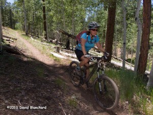
Biking the Rainbow Rim Trail along the edge of the Grand Canyon

In late June we packed our bikes and camping gear and headed to the Kaibab Plateau so we could mountain bike on the Rainbow Rim Trail. We’ve done this trail before but it’s such a great ride with amazing views that it’s always worth the long drive.

It takes about four hours to get to the trail head from Flagstaff. The last hour of driving is on Forest Service gravel roads through the aspen, pine, spruce, and fir forests of the high plateau of the Kaibab. We went to the south end of the trail at Timp Point and set up camp on the edge of the rim overlooking the Grand Canyon. After a quick lunch we were on the trail heading north.

The Rainbow Rim Trail (RRT) is about 18 miles from end to end with five points along the trail. From south to north they are Timp Point, North Timp Point, Locust Point, Fence Point, and Parissawampitts Point.

Riding along the edge of the Grand Canyon on the Rainbow Rim Trail.

Each point delivers you a stunning view of the Grand Canyon. Between the points the trail heads in a generally eastward direction as it contours around side canyons. And it is these side canyons that are the most interesting. Because they are oriented east-west there is substantial shade in the canyons resulting in a cooler micro-climate. The south and shady sides of these canyons are filled with aspen groves as well as spruce and fir trees while the sunnier north sides have ponderosa pine and even juniper and pinyon trees. We even found some wild strawberry plants.

Lush forest found in the side canyons traversed by the Rainbow Rim Trail.

There are no large cities near the Kaibab Plateau hence there are no city lights. The nights are exceptionally dark and the stars are brilliant. Take some time to just lie back and stare up at the sky. It’s good for your soul.

The night sky as seen from the Kaibab Plateau.

The Arizona Trail (AZT) also traverses the Kaibab Plateau. Whereas the RRT is along the west edge of the Plateau the AZT is closer to the east edge but only overlooks the edge of the canyon in one location. In that regard, the RRT trumps the AZT.

The Jacob Lake District of the Kaibab National Forest has an informational page about this trail including access points, maps, and mileage.

Hiking the Grand Canyon: Rim to Rim* to Rim

I have always wanted to hike the Rim-to-Rim-to-Rim traverse of the Grand Canyon. That is, start at one Rim, hike down to the Colorado River, hike up to the opposite Rim, then reverse back to the beginning.

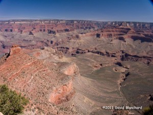
From the South Kaibab Trail the North Rim is a long ways away...
From the South Kaibab Trail the North Rim is a long ways away…

I’ve done a single traverse before from the North Rim to the South Rim but never the R2R2R as it’s called. On the other hand, my significant other has done it a couple of times and keeps asking me to join her. So last week we set out to walk (WALK, not RUN!) the R2R2R of the Grand Canyon. We started mid morning on the South Rim and descended the South Kaibab Trail. Being in no hurry, we took a comfortable pace so that we could actually enjoy the hike and scenery. The weather was pleasant: clear skies, breezy, a bit cool at the top and a bit warm at the bottom.

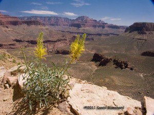
There were many flowers in bloom along the trail. This is "Prince's Plume."
There were many flowers in bloom along the trail. This is “Prince’s Plume.”

After a refreshing stop at Phantom Ranch where we had lunch and drank plenty of fluids we began the hike up the North Kaibab Trail to the North Rim. The last of the spring snowmelt was rushing down Bright Angel Creek and the roar of the water was loud enough to make conversation difficult. Crossing the stream would have been foolish but there is no need: all crossings have well- built bridges.

Still a long way to go to reach the Colorado River.

By the time we reached Cottonwood campground it was time to eat again and we had dinner as the sun slipped below the high walls of Bright Angel Canyon. The wind, which normally diminishes in the evening, became stronger. First it was annoying, then it became strong enough to blow dirt. Finally, as we were a mile or so above Roaring Springs, the wind nearly blew me off my feet. The sun had already set and it was quite dark as we climbed this part of the trail. It’s narrow with substantial cliffs on the side. The thought of being blown off my feet and… well, you know… was unnerving. So, with only about 3 1/2 miles to go, we decided to err on the side of safety and we turned back.

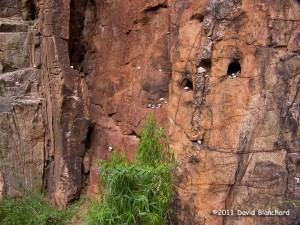
Rock art in Bright Angel Canyon. Hikers had placed these small stones in the canyon wall.

We walked in the dark until about midnight and then took a nap on a queen-sized flat rock. Never thought I could fall asleep on a rock but it was easy. I awoke to stare at the stars and listen to the thundering of the water in Bright Angel Creek. What a magnificent place to be! Just the two of us — and whatever wild creatures may have been watching us.

We walked back to Phantom Ranch and the Colorado River and then began the difficult climb back up South Kaibab Trail. About halfway up we had a magnificent sunrise. Not too much later we saw some long-distance runners heading downhill towards us. We chatted for a minute and gave them some information on trail conditions. And then they were off.

If we had done this a day earlier, we would have seen two women running R2R2R in an attempt to beat the “Fastest Known Time” for women on this trail. And they succeeded!

And just a few days later the record was broken again!

I’m happy to walk the R2R2R. Running not required.