Thundersnow!

Thundersnow. Just the sound of it is exciting—snow accompanied by thunder and lightning. Although it is fairly rare east of the Rocky Mountains it is a bit more common across the west.

And we had multiple rounds of thunderstorms producing snow yesterday (Saturday, 13 February 2021) in Flagstaff. It was pretty amazing to see heavy snow falling and then a sudden flash of lightning followed by the muffled sound of thunder a few seconds later.
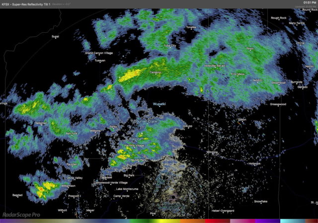
Radar depiction of precipitation across northern Arizona at 1:51 P.M. on 13 February 2021. Note the small lightning symbols near Flagstaff showing locations of cloud-to-ground lightning.

There were several clusters of thunderstorms that moved across the area during the afternoon. None of these were recorded by the ASOS at KFLG—and it’s not obvious why they were missed. The ASOS certainly captured the start of snow and then the moderate (SN) and heavy snow (+SN). Perhaps the lightning was just far enough away to not register.

KFLG 132307Z VRB06G25KT M1/4SM +SN FZFG VV004 M01/M02 A2960 RMK AO2 P0006 T10111017
KFLG 132257Z 29009G27KT 260V340 1/4SM SN FZFG VV005 M01/M01 A2961 RMK AO2 PK WND 24031/2239 SLP027 P0007 T10061011
KFLG 132243Z 27012G31KT 1/4SM SN FG BKN008 OVC029 00/M01 A2959 RMK AO2 PK WND 24031/2239 P0004 T00001006

Here is a loop of the visible channel from the GOES-17 satellite. Superimposed on the clouds are color blobs showing Group Flash Count Density from the satellite lightning mapper. The next image shows lighting from surface-based lightning detectors and shows numerous cloud-to-ground strikes across northern Arizona.
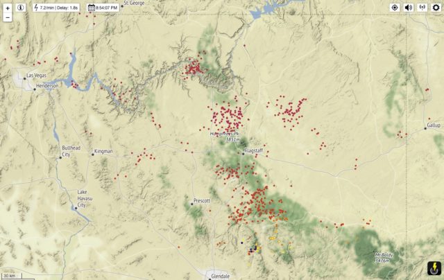
 

Locations of cloud-to-ground lightning across northern Arizona on the afternoon of 13 February 2021.

Model-generated soundings from the HRRR showed that there was very slight convective instability with surface-based CAPE values of around 100 J/kg.
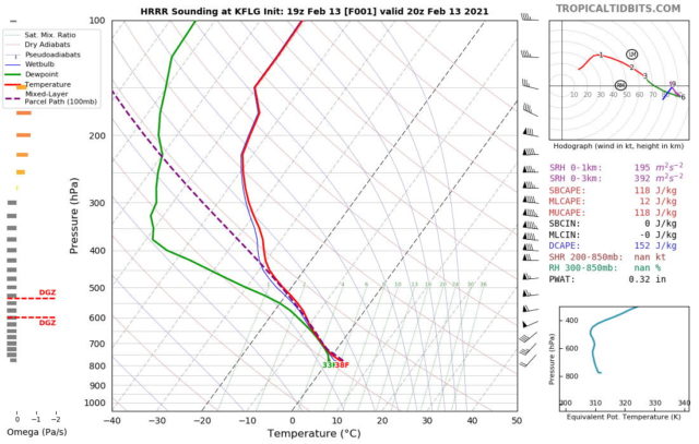
Model-derived sounding for Flagstaff at 20 UTC 13 February 2021 (1300 MST)

That is a shallow layer of instability and very weak instability—but was enough to generate thundersnow.

Thundersnow in Flagstaff

It has been a dry October and the last measurable precipitation at the Flagstaff airport was September 26 until rain and snow fell on Sunday, October 27.

Forecast models had been showing a slight chance of rain and/or snow with the passage of a cold front but precipitation amounts were light. The GEFS plumes showed generally less than 0.03 inches. The airport actually measured a bit more than that as 0.05″ of rain fell with a trace of snow.

Radar depiction of rain and snow moving across northern Arizona (2019_1028_2235).
24-hour lightning map.
GEFS plume forecast for Flagstaff.

Overall, not a bad forecast. So I was not surprised that rain and some snow arrived with the cold front. I was surprised that it was accompanied by thunder and lightning.

It’s always interesting to observe Thundersnow!

A look at the lightning map shows that the only place where there was cloud-to-ground lightning was in the vicinity of Flagstaff.

And now we return to our dry weather pattern.